SFO RELO
  • Home
  • Neighborhoods
  • SF School System
  • SF Schools
  • Resources
  • Activities
  • FAQ
  • Buyer Info

SF Neighborhoods

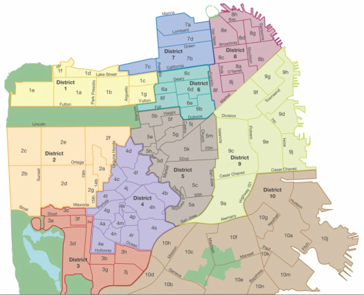
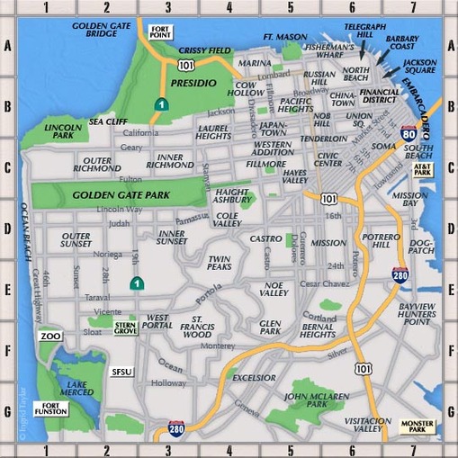
San Francisco is made up of many neighborhoods each with their own character, personalities, and history.  Below you will find three different neighborhood maps to help you find the perfect neighborhood that matches your personality.  The first map is a general neighborhood map which defines many of the local popular neighborhoods by name.  The second map is a zip code map that shows you which zip codes correspond for which neighborhoods.  The third map is a San Francisco district map which breaks down the city by how realtors and property owners view the city.  This third map is what you should use when looking to buy or rent a place as your real estate professional will know exactly what neighborhoods you are interested in living.

 
Neighborhoods (General Overview)

Alamo Square
Barbary Coast
Bayview/Hunter's Point
Bernal Heights
Castro
Central Richmond
Central Sunset
China Town
Civic Center
Cole Valley
Cow Hollow
Dog Patch
Dolores Heights
Downtown
Embarcadero
Eureka Valley
Excelsior
Fillmore
Financial District
Fisherman's Wharf
Glen Park
Haight Ashbury
Hayes Valley
Inner Mission
Inner Richmond
Inner Sunset
Jackson Square
Japan Town
Jordan Park
Lake
Laurel Heights
Lower Pacific Heights
Marina
Miraloma Park
Mission
Mission Bay
Nob Hill
Noe Valley
North Beach
North Panhandle (NOPA)
North Waterfront
Outer Richmond
Outer Sunset
Pacific Heights
Potrero Hill
Presidio
Presidio Heights
Russian Hill
Sea Cliff
SOMA
South Beach
Sunnyside
St. Francis Wood
Telegraph Hill
Tenderloin
Twin Peaks
Union Square
Visitation Valley
West Portal
Western Addition
Yerba Buena

Picture
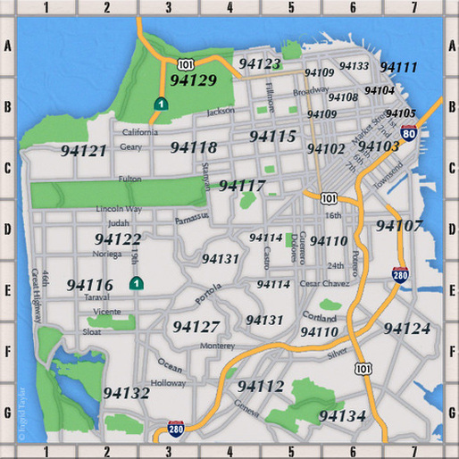
Zip Code (General Guide)

94102 Civic Center, Downtown, Hayes
          Valley, Tenderloin
94103  South of Market (SOMA) Yerba
           Buena
94104 Financial District
94105 South Beach
94107 Dog Patch, Mission Bay, South
          Beach
94108 China Town, Nob Hill, Union Square
94109 Polk Gultch, Russian Hill
94110 Inner Mission, Mission District
94112 Balboa Pk, City College, Crocker
          Amazon, Excelsior, Ingleside,
          Sunnyside
94114 Castro, Noe Valley, Upper Market
94115 Cow Hollow, Pacific Heights, Lower           Pacific Heights, Western Addition
94116 Parkside
94117 Cole Valley,  Diamond Heights,
          Duboce Triangle, Haight Ashbury
94118 Inner Richmond, Jordan Park,
          Laurel Heights, Presidio Heights
94121 Outer Richmond
94122 Central Sunset, Inner Sunset, Outer           Sunset
94123 Marina
94124 Bayview, Hunter's Point
94127 Twin Peaks, West Portal
94129 Presidio
94132 St Francis Wood, Stonestown
94133 China Town, Fisherman's Wharf,
          Nob Hill, North Beach
94134 Portola, Visitacion Valley

Picture
Districts (actual neighborhoods as defined by the San Francisco Association of Realtors)

1a Central Richmond
1b Inner Richmond
1c Jordan Park, Laurel Heights
1d Lake
1e Outer Richmond
1f Sea Cliff
1g Lone Mountain
2a Golden Gate Heights
2b Outer Parkside
2c Outer Sunset
2d Parkside
2e Central Sunset
2f Inner Sunset
2g Inner Parkside
3a Lake Shore
3b Merced Heights
3c Pine Lake Park
3d Stonestown
3e Lakeside
3f Merced Manor
3g Ingleside Heights
3h Ingleside
3j Oceanview
4a Balboa Terrace
4b Diamond Heights
4c Forest Hills
4d Forest Knolls
4e Ingleside Terrace
4f Midtown Terrace
4g St. Francis Wood
4h Miraloma Park
4j Forest Hill Extension
4k Sherwood Forest
4m Monterey Heights
4n Mount Davidson Manor
4p Westwood Highlands
4r Westwood Park
4s Sunnyside
4t West Portal
5a Glen Park
5b Haight Ashbury
5c Noe Valley
5d Twin Peaks
5e Cole Valley/Parnassus Heights
5f Buena Vista Park/Asbury Heights
5g Corona Heights
5h Clarendon Heights
5j Duboce Triangle
5k Eureka Valley, Dolores Heights
5m Mission Dolores
6a Anza Vista
6b Hayes Valley
6c Lower Pacific Heights
6d Western Addition
6e Alamo Square
6f  North Panhandle
7a Marina
7b Pacific Heights
7c Presidio Heights
7d Cow Hollow
8a Downtown
8b Financial District
8c Nob Hill
8d North Beach
8e Russian Hill
8f Van Ness, Civic Center
8g Telegraph Hill
8h North Waterfront
8j Tenderloin
9a Bernal Heights
9c Inner Mission
9d Mission Bay
9e Potrero Hill
9f South of Market
9g Yerba Buena
9h South Beach
9j Central Waterfront/Dogpatch
10a Bayview
10b Crocker Amazon
10c Excelsior
10d Outer Mission
10e Visitacion Valley
10f Portola
10g Silver Terrace
10h Mission Terrace
10j Hunter's Point
10k Bayview Heights
10m Candlestick Point
10n Little Hollywood
Picture
                         Detailed Map of all the San Francisco Districts/Subdistricts and Streets
SFO RELO
© 2017 SFO RELO. All Rights Reserved. All information presented on this web page is for information purposes only but is not guaranteed and should be independently verified by the users of this site. SFO RELO makes no warranty, either expressed or implied, as to the accuracy of the data contained within or obtained from this Web Page.